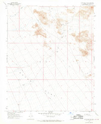
1967 Map of Dutch Flat NW
USGS Topo · Published 1969About this map
Dutch Flat dominates this high desert landscape in Mohave County, where the topography transitions from the open alluvial floor to the rocky ridges of the north and east. The 17 Mile Ranch serves as the primary landmark in this arid expanse, situated near a Landing Strip and Dry Well, indicating the remote nature of human habitation and aviation in the region during the late 1960s. The drainage of Cow Creek cuts across the northern boundary, while a network of Jeep Trails and the established Alamo Road provide the only access routes through the basin. This survey documents the area just as aerial photogrammetry was refining the mapping of the American West, capturing a landscape defined by sparse water resources like the various Water Tanks scattered along the trail systems.
Find a feature on this map
12 named features on this map. Tap any name to fly to it.
Don’t see what you’re looking for? This feature index may not catch every label — zoom into the map to look around manually.
Map Details
Editions of this 1967 Dutch Flat NW Map
This is the sole edition of this map. No revisions or reprints were ever made.
Other maps of this area

1923 · Signal
USGS Topo · 1:250,000

1927 · Yucca
USGS Topo · 1:62,500

1927 · Buck Mountains
USGS Topo · 1:62,500

1929 · Buck Mountains
USGS Topo · 1:62,500

1929 · Yucca
USGS Topo · 1:62,500

1942 · Signal
USGS Topo · 1:250,000

1950 · Prescott
USGS Topo · 1:250,000

1954 · Needles
USGS Topo · 1:250,000

1954 · Prescott
USGS Topo · 1:250,000

1956 · Needles
USGS Topo · 1:250,000