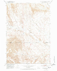
1951 Map of Dutch Nick Flat NW
USGS Topo · Published 1973About this map
Mueller Cabin sits as a lonely human landmark in this high desert landscape, mapped during a 1951 field check as part of the Missouri River Basin development program. The terrain is defined by an intricate network of seasonal drainages, where Fifteen Mile Creek and Rock Waterhole Creek carve deep into the plateau. The survey reveals a sparsely populated corner of the Bighorn Basin, where the boundary between Big Horn Co and Washakie Co cuts across the southern ridges. Travel through the region is marked by the rugged Fenton Pass Road, which traces the high ground above Bobcat Draw. This map records the land as it existed before modern shifts in ranching and resource extraction, capturing a period when small outposts like the cabin were essential markers for navigation and land use in the Wyoming interior.
Find a feature on this map
8 named features on this map. Tap any name to fly to it.
Don’t see what you’re looking for? This feature index may not catch every label — zoom into the map to look around manually.
Map Details
Editions of this 1951 Dutch Nick Flat NW Map
2 editions found
Other maps of this area

1951 · Sucker Dam
USGS Topo · 1:24,000

1951 · Dutch Nick Flat
USGS Topo · 1:24,000

1951 · Dutch Nick Flat SW
USGS Topo · 1:24,000

1951 · Gillies Draw
USGS Topo · 1:24,000

1951 · Sheep Mountain
USGS Topo · 1:24,000

1951 · Tatman Mountain
USGS Topo · 1:24,000

1951 · Wardel Reservoir
USGS Topo · 1:24,000

1951 · Dead Indian Hill
USGS Topo · 1:24,000

1951 · Dutch Nick Flat NW
USGS Topo · 1:24,000

1955 · Cody
USGS Topo · 1:250,000