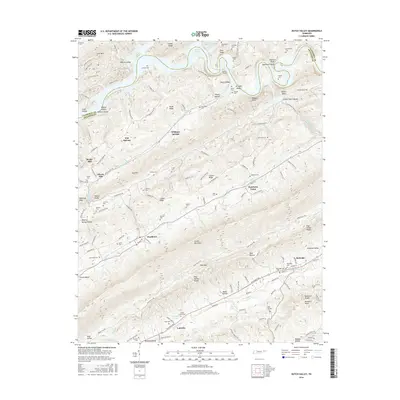
2016 Map of Dutch Valley
USGS Topo · Published 2016About this map
Clinch Mountain and Copper Ridge dominate this section of East Tennessee, defining a series of parallel valleys where communities like Washburn and Rutledge were established. The landscape is heavily marked by family history, with dozens of small burial grounds such as Janeway Cem, Arnwine Cem, and Seymoure Cem scattered across the ridges. Evidence of historical infrastructure and industry appears in the form of Beeler Mill and the Oakman Tunnel, which cuts through River Ridge near the winding course of Norris Lake. The settlement pattern follows the natural corridors of Richland Valley and Dutch Valley, where secondary roads like Rutledge Pike and Old Stage Coach Rd connect the isolated hollows. This 2016 survey documents the enduring rural character of the Claiborne and Grainger county line, showing how modern development still adheres to the primary landforms of the Great Valley.
Find a feature on this map
128 named features on this map. Tap any name to fly to it.
Don’t see what you’re looking for? This feature index may not catch every label — zoom into the map to look around manually.
Map Details
Editions of this 2016 Dutch Valley Map
This is the sole edition of this map. No revisions or reprints were ever made.
Other maps of this area

1883 · Morristown
USGS Topo · 1:125,000

1893 · Morristown
USGS Topo · 1:125,000

1895 · Morristown
USGS Topo · 1:125,000

1897 · Maynardville
USGS Topo · 1:125,000

1900 · Maynardville
USGS Topo · 1:125,000

1935 · Luttrell
USGS Topo · 1:24,000

1935 · Tate Springs
USGS Topo · 1:48,000

1935 · Straw Plains
USGS Topo · 1:48,000

1935 · Joppa
USGS Topo · 1:24,000

1935 · Howard Quarter
USGS Topo · 1:24,000