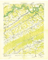
1936 Map of Dutch Valley
USGS Topo · Published 1936About this map
Norris Reservoir dominates the northern reaches of this mid-1930s landscape, illustrating the transformative impact of the Tennessee Valley Authority on the Clinch River valley. The terrain is defined by parallel ridges including Comby Ridge and Clinch Mountain, which channel the region's agricultural and social life into narrow corridors like Dutch Valley Creek and Poor Valley. These valleys are dotted with small social hubs such as Dutch and Liberty Hill, where Liberty Hill Sch and Beeler Chapel served the local farming community.
Find a feature on this map
64 named features on this map. Tap any name to fly to it.
Don’t see what you’re looking for? This feature index may not catch every label — zoom into the map to look around manually.
Map Details
Editions of this 1936 Dutch Valley Map
This is the sole edition of this map. No revisions or reprints were ever made.
Other maps of this area

1883 · Morristown
USGS Topo · 1:125,000

1893 · Morristown
USGS Topo · 1:125,000

1895 · Morristown
USGS Topo · 1:125,000

1897 · Maynardville
USGS Topo · 1:125,000

1900 · Maynardville
USGS Topo · 1:125,000

1935 · Luttrell
USGS Topo · 1:24,000

1935 · Tate Springs
USGS Topo · 1:48,000

1935 · Straw Plains
USGS Topo · 1:48,000

1935 · Joppa
USGS Topo · 1:24,000

1935 · Howard Quarter
USGS Topo · 1:24,000