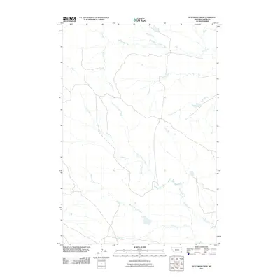
2011 Map of Dutchman Creek
USGS Topo · Published 2011About this map
Dutchman Creek and its complex network of seasonal tributaries define this corner of Carter County, Montana. The landscape is dominated by the intricate drainage systems of Corral Creek, which branches into its North Fork and South Fork. In this sparsely populated area, human activity is primarily indicated by a limited road network, most notably Ridge Rd, which follows the higher ground between watercourses. Other distinct watersheds like Cabin Creek, Flat Creek, and South Creek cross the eastern and northern portions of the map. This topographic survey captures the natural contours and hydraulic patterns of the Montana plains as they appeared in the early 21st century, illustrating how the terrain's dry-land hydrology dictates the placement of rural infrastructure.
Find a feature on this map
10 named features on this map. Tap any name to fly to it.
Don’t see what you’re looking for? This feature index may not catch every label — zoom into the map to look around manually.
Map Details
Editions of this 2011 Dutchman Creek Map
This is the sole edition of this map. No revisions or reprints were ever made.
Other maps of this area

1954 · Ekalaka
USGS Topo · 1:250,000

1956 · Ekalaka
USGS Topo · 1:250,000

1958 · Ekalaka
USGS Topo · 1:250,000

1965 · Ekalaka
USGS Topo · 1:250,000

1979 · W L Butte
USGS Topo · 1:24,000

1979 · Dutchman Creek
USGS Topo · 1:24,000

1979 · Dead Boy Divide
USGS Topo · 1:24,000

1979 · Ikey Creek
USGS Topo · 1:24,000

1979 · Chalk Buttes
USGS Topo · 1:24,000
1979 · Davis Creek East
USGS Topo · 1:24,000