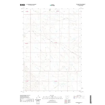
2020 Map of Dutchman Creek
USGS Topo · Published 2020About this map
Blue Mud Hills anchor the northern reaches of this remote Carter County landscape, where the high ground transitions into a complex web of seasonal drainages. The area is defined by its watershed geography, with Dutchman Cr and Cabin Cr carving through the terrain alongside several branches of the Corral Creek system. This 2020 survey illustrates a sparsely populated ranching environment where movement is dictated by the singular path of Ridge Rd, which winds along the local divides to connect the high points of the territory. The map provides a precise view of public land survey boundaries, including t2s r57e and t3s r57e, marking out the sectional divisions that have organized this part of Montana for over a century. Water remains the primary landmark here, with named features like Flat Cr and Ikey Cr serving as the few fixed points in an otherwise open range.
Find a feature on this map
17 named features on this map. Tap any name to fly to it.
Don’t see what you’re looking for? This feature index may not catch every label — zoom into the map to look around manually.
Map Details
Editions of this 2020 Dutchman Creek Map
This is the sole edition of this map. No revisions or reprints were ever made.
Other maps of this area

1954 · Ekalaka
USGS Topo · 1:250,000

1956 · Ekalaka
USGS Topo · 1:250,000

1958 · Ekalaka
USGS Topo · 1:250,000

1965 · Ekalaka
USGS Topo · 1:250,000

1979 · W L Butte
USGS Topo · 1:24,000

1979 · Dutchman Creek
USGS Topo · 1:24,000

1979 · Dead Boy Divide
USGS Topo · 1:24,000

1979 · Ikey Creek
USGS Topo · 1:24,000

1979 · Chalk Buttes
USGS Topo · 1:24,000
1979 · Davis Creek East
USGS Topo · 1:24,000