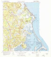
1974 Map of Duxbury
USGS Topo · Published 1978About this map
The Nook and the complex salt marshes of Duxbury Marsh define this coastal landscape as it appeared in the mid-1970s. The map serves as a significant record of early colonial heritage, specifically marking the John Alden House and the Governor Winslow House. Significant attention is given to the legacy of the Standish family, with labels for the Myles Standish Monument, the Site of Myles Standish Homestead, and the Old Burying Ground containing the grave of the famous Pilgrim leader. The coastline is characterized by protective barriers like Duxbury Beach and Saquish Neck, which shelter Duxbury Bay and Kingston Bay. Inland, the area shows a transition from traditional cranberry cultivation in numerous Cranberry Bogs to residential developments near Tree of Knowledge Corner and Tinkertown. The Marshfield Fairgrounds and the Marshfield Municipal Airport reflect the established community infrastructure of the era.
Find a feature on this map
119 named features on this map. Tap any name to fly to it.
Don’t see what you’re looking for? This feature index may not catch every label — zoom into the map to look around manually.
Map Details
Editions of this 1974 Duxbury Map
2 editions found
Other maps of this area

1885 · Abington
USGS Topo · 1:62,500

1885 · Duxbury
USGS Topo · 1:62,500

1885 · Middleboro
USGS Topo · 1:62,500

1886 · Plymouth
USGS Topo · 1:62,500

1888 · Duxbury
USGS Topo · 1:62,500

1888 · Middleboro
USGS Topo · 1:62,500

1888 · Abington
USGS Topo · 1:62,500

1889 · Plymouth
USGS Topo · 1:62,500

1893 · Abington
USGS Topo · 1:62,500

1893 · Duxbury
USGS Topo · 1:62,500