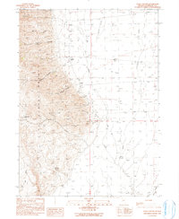
1990 Map of Dyke Canyon
USGS Topo · Published 1990About this map
Pine Forest Range dominates the western skyline of this northern Nevada landscape, where steep canyons and high-desert drainage basins converge. The map documents the remnants of human activity along the mountain front, most notably at the Dyke (Site) and nearby Woodward Ranch. A small Cem and the Dyke Hot Springs suggest the historical importance of this specific location for travelers and early settlers in Humboldt County.
Find a feature on this map
21 named features on this map. Tap any name to fly to it.
Don’t see what you’re looking for? This feature index may not catch every label — zoom into the map to look around manually.
Map Details
Editions of this 1990 Dyke Canyon Map
This is the sole edition of this map. No revisions or reprints were ever made.
Other maps of this area

1886 · Disaster
USGS Topo · 1:250,000

1893 · Disaster
USGS Topo · 1:250,000

1954 · Vya
USGS Topo · 1:250,000

1958 · Vya
USGS Topo · 1:250,000

1961 · Quinn River Crossing
USGS Topo · 1:62,500

1961 · Bottle Creek
USGS Topo · 1:62,500

1962 · Vya
USGS Topo · 1:250,000

1965 · Duffer Peak
USGS Topo · 1:62,500

1972 · Deer Creek Slough
USGS Topo · 1:24,000

1972 · Leonard Cr. Slough North
USGS Topo · 1:24,000