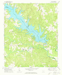
1971 Map of Dyson
USGS Topo · Published 1973About this map
The Saluda River and the sprawling waters of Lake Greenwood define the landscape of this 1971 survey, where the borders of Laurens, Greenwood, Newberry, and Saluda counties meet. The shoreline is punctuated by development like Greenwood Shores and the expansive Greenwood State Park, reflecting the mid-century transition toward recreational land use along the dammed river. Inland, the settlement pattern remains anchored by small communities and rural intersections such as Dyson, Vaughanville, and Chappells.
Find a feature on this map
34 named features on this map. Tap any name to fly to it.
Don’t see what you’re looking for? This feature index may not catch every label — zoom into the map to look around manually.
Map Details
Editions of this 1971 Dyson Map
This is the sole edition of this map. No revisions or reprints were ever made.
Other maps of this area

1892 · Abbeville
USGS Topo · 1:125,000

1908 · Kirksey
USGS Topo · 1:24,000

1941 · Spartanburg
USGS Topo · 1:250,000

1949 · Ninety-Six
USGS Topo · 1:24,000

1950 · Kirksey
USGS Topo · 1:24,000

1953 · Spartanburg
USGS Topo · 1:250,000

1954 · Greenville
USGS Topo · 1:250,000

1958 · Greenville
USGS Topo · 1:250,000

1960 · Spartanburg
USGS Topo · 1:250,000

1963 · Spartanburg
USGS Topo · 1:250,000