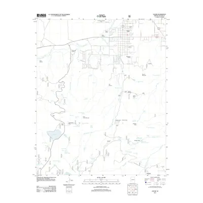
2011 Map of Eagar
USGS Topo · Published 2011About this map
The town of Eagar serves as the hub of this high-altitude landscape in eastern Arizona, situated within the geographic expanse of Round Valley. The settlement pattern follows a grid north of Water Canyon Creek, while the southern reaches of the quadrangle transition into a complex network of canyons and water management features. The local reliance on water resources is evident in the numerous tanks, springs, and reservoirs, such as Atcheson Reservoir and Little George Reservoir, which dot the terrain alongside the winding path of the Little Colorado River.
Find a feature on this map
100 named features on this map. Tap any name to fly to it.
Don’t see what you’re looking for? This feature index may not catch every label — zoom into the map to look around manually.
Map Details
Editions of this 2011 Eagar Map
This is the sole edition of this map. No revisions or reprints were ever made.
Other maps of this area

1886 · St Johns
USGS Topo · 1:250,000

1892 · St Johns
USGS Topo · 1:250,000

1922 · Nutrioso
USGS Topo · 1:125,000

1954 · Clifton
USGS Topo · 1:250,000

1954 · Saint Johns
USGS Topo · 1:250,000

1957 · Clifton
USGS Topo · 1:250,000

1957 · Saint Johns
USGS Topo · 1:250,000

1958 · Clifton
USGS Topo · 1:250,000

1958 · Saint Johns
USGS Topo · 1:250,000

1958 · Alpine
USGS Topo · 1:62,500