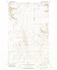
1972 Map of Eagle Buttes SW
USGS Topo · Published 1975About this map
Sherry Coulee and the winding drainage of Crow Coulee dominate the high plains of Chouteau County in this early 1970s topographic record. The landscape is characterized by its dramatic erosion patterns, where deep coulees cut through the flat agricultural benchlands typical of north-central Montana. Mapping by the Geological Survey during this era reveals the subtle topographic relief and the complex network of intermittent watercourses that defined the local hydrology before modern intensive land management. While the map is sparse in named settlements, the intricate contour work provides an essential record for understanding the natural drainage systems and terrain that dictated early ranching and homesteading patterns in this portion of the state.
Find a feature on this map
2 named features on this map. Tap any name to fly to it.
Don’t see what you’re looking for? This feature index may not catch every label — zoom into the map to look around manually.
Map Details
Editions of this 1972 Eagle Buttes SW Map
This is the sole edition of this map. No revisions or reprints were ever made.
Other maps of this area

1890 · Fort Benton
USGS Topo · 1:250,000

1892 · Fort Benton
USGS Topo · 1:250,000

1897 · Fort Benton
USGS Topo · 1:250,000

1953 · Eagle Buttes
USGS Topo · 1:24,000

1953 · Big Bend School
USGS Topo · 1:24,000

1953 · Pilot Rock
USGS Topo · 1:24,000

1953 · Stranahan
USGS Topo · 1:24,000

1954 · Great Falls
USGS Topo · 1:250,000

1957 · Great Falls
USGS Topo · 1:250,000
1972 · Stranahan SE
USGS Topo · 1:24,000