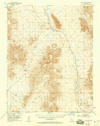
1951 Map of Eagle Mtn
USGS Topo · Published 1959About this map
Lila C Mine (Site) and the small settlement of Evelyn mark a landscape of early 20th-century extraction in Inyo County. This 1951 field-checked survey documents a transition period for the region's industrial infrastructure, most notably showing a Dismantled Railroad that once served the borax mining industry and the faint trace of the Old Traction Road crossing the northern wastes. These transportation relics follow the course of the Amargosa River, which cuts through the arid basin between the Greenwater Range and the Resting Spring Range.
Find a feature on this map
19 named features on this map. Tap any name to fly to it.
Don’t see what you’re looking for? This feature index may not catch every label — zoom into the map to look around manually.
Map Details
Editions of this 1951 Eagle Mtn Map
3 editions found

Other maps of this area

1908 · Furnace Creek
USGS Topo · 1:250,000

1910 · Furnace Creek
USGS Topo · 1:250,000

1933 · Avawatz Mountains
USGS Topo · 1:250,000

1940 · Eagle Tank
USGS Topo · 1:62,500

1947 · Trona
USGS Topo · 1:250,000

1948 · Trona
USGS Topo · 1:250,000

1948 · Death Valley
USGS Topo · 1:250,000

1950 · Confidence Hills
USGS Topo · 1:62,500

1950 · Tecopa
USGS Topo · 1:62,500

1951 · Tecopa
USGS Topo · 1:62,500