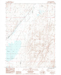
1985 Map of Eagle Rock
USGS Topo · Published 1985About this map
The California Emigrant Trail cuts a historic path across this arid stretch of Nevada, tracing the grueling journey through the Forty Mile Desert. The landscape is dominated by saline features and early industrial attempts to harvest them, including the Eagle Salt Works (Site) and nearby Abandoned Salt Evaporators. These sites, along with the Leete (Site) settlement, illustrate the 19th-century reliance on mineral extraction in this demanding environment. To the south, the Fernley Sink and the surrounding Fernley Wildlife Management Area represent the hydrology of the Great Basin, where seasonal waters gather in an Alkali Flat between the Truckee Range and the Hot Springs Mountains. The presence of a Geothermal well and various Salt Wells further indicates the subterranean activity and resource potential of this high-desert terrain.
Find a feature on this map
21 named features on this map. Tap any name to fly to it.
Don’t see what you’re looking for? This feature index may not catch every label — zoom into the map to look around manually.
Map Details
Editions of this 1985 Eagle Rock Map
This is the sole edition of this map. No revisions or reprints were ever made.
Other maps of this area

1890 · Wadsworth
USGS Topo · 1:125,000

1892 · Wadsworth
USGS Topo · 1:125,000

1894 · Wadsworth
USGS Topo · 1:125,000

1908 · Carson Sink
USGS Topo · 1:250,000

1910 · Carson Sink
USGS Topo · 1:250,000

1951 · Soda Lake
USGS Topo · 1:62,500

1951 · Desert Peak
USGS Topo · 1:62,500

1957 · Fireball Ridge
USGS Topo · 1:62,500

1957 · Two Tips
USGS Topo · 1:62,500

1957 · Reno
USGS Topo · 1:250,000