
1957 Map of Two Tips
USGS Topo · Published 1959About this map
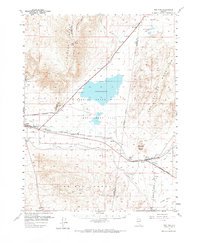
The Fernley State Wildlife Management Area occupies a central role in this high-desert landscape, where irrigation engineering and rail infrastructure meet the alkaline sinks of the Great Basin. The Truckee Canal and the Fernley Drain illustrate the intensive mid-century efforts to manage water for agriculture and conservation across the Alkali Flat. To the south, the Southern Pacific railroad corridor serves as the primary artery for local life, anchoring the junction at Hazen and smaller stops like Argo and Darwin. The topography is dominated by the Truckee Range and Virginia Range, providing a stark backdrop to the industrial operations at the Salt Evaporators and several prospects scattered near the peaks. This survey offers a clear look at how the region's transport and water networks were integrated into the natural desert terrain during the late 1950s.
Find a feature on this map
33 named features on this map. Tap any name to fly to it.
Don’t see what you’re looking for? This feature index may not catch every label — zoom into the map to look around manually.
Map Details
Editions of this 1957 Two Tips Map
2 editions found
Other maps of this area

1890 · Wadsworth
USGS Topo · 1:125,000

1891 · Wabuska
USGS Topo · 1:125,000

1892 · Wadsworth
USGS Topo · 1:125,000

1894 · Wadsworth
USGS Topo · 1:125,000

1894 · Wabuska
USGS Topo · 1:125,000

1908 · Carson Sink
USGS Topo · 1:250,000

1910 · Carson Sink
USGS Topo · 1:250,000

1951 · Soda Lake
USGS Topo · 1:62,500

1951 · Desert Peak
USGS Topo · 1:62,500

1951 · Fallon
USGS Topo · 1:62,500