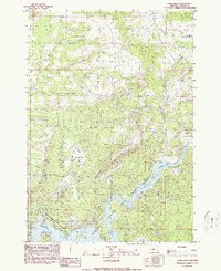
1990 Map of Eagle Rock
USGS Topo · Published 1990About this map
The Crooked River dominates the southern landscape of this Crook County quadrangle, where the impounded waters form the Prineville Reservoir. This 1990 edition highlights the extensive public lands managed as the Prineville Reservoir State Wildlife Area and the adjacent Prineville Reservoir State Park. The terrain shifts from the canyon depths of the reservoir to the high elevations of the Ochoco National Forest in the northeast corner. Notable geological landmarks like Eagle Rock and the broad expanse of Combs Flat characterize the area's physical geography. Evidence of local infrastructure includes the Boa Ramp for water access and a small Gravel Pit near Eagle Creek, reflecting the intersection of recreation and small-scale resource extraction in central Oregon.
Find a feature on this map
19 named features on this map. Tap any name to fly to it.
Don’t see what you’re looking for? This feature index may not catch every label — zoom into the map to look around manually.
Map Details
Editions of this 1990 Eagle Rock Map
This is the sole edition of this map. No revisions or reprints were ever made.
Other maps of this area

1946 · Eagle Rock
USGS Topo · 1:62,500

1948 · Eagle Rock
USGS Topo · 1:62,500

1948 · Ochoco Reservoir
USGS Topo · 1:62,500

1950 · Ochoco Reservoir
USGS Topo · 1:62,500

1955 · Bend
USGS Topo · 1:250,000

1957 · Bend
USGS Topo · 1:250,000

1958 · Bend
USGS Topo · 1:250,000

1962 · Prineville
USGS Topo · 1:24,000

1962 · Powell Buttes
USGS Topo · 1:62,500

1962 · Prineville
USGS Topo · 1:62,500