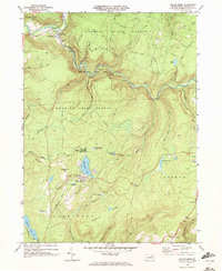
1969 Map of Eagles Mere
USGS Topo · Published 1972About this map
Eagles Mere Lake serves as a central landmark in this Sullivan County highland, a place where late-1960s recreational development meets the deep wilderness of the Wyoming State Forest. The map illustrates a landscape of high plateaus and sharp drainage, notably at Worlds End State Park where Loyalsock Creek carves a sharp S-curve beneath Canyon Vista. This era shows the borough of Eagles Mere as a well-established resort community, complete with its Golf Course and Eagles Mere Park.
Find a feature on this map
53 named features on this map. Tap any name to fly to it.
Don’t see what you’re looking for? This feature index may not catch every label — zoom into the map to look around manually.
Map Details
Editions of this 1969 Eagles Mere Map
2 editions found
Other maps of this area

1927 · Eagles Mere
USGS Topo · 1:48,000

1932 · Eagle Mere
USGS Topo · 1:62,500

1934 · Laporte
USGS Topo · 1:62,500

1943 · Monroeton
USGS Topo · 1:62,500

1943 · Powell
USGS Topo · 1:62,500

1945 · Powell
USGS Topo · 1:62,500

1953 · LaPorte
USGS Topo · 1:62,500

1953 · Eagles Mere
USGS Topo · 1:62,500

1954 · Williamsport
USGS Topo · 1:250,000

1960 · Williamsport
USGS Topo · 1:250,000