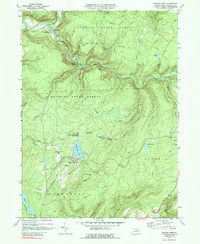
1969 Map of Eagles Mere
USGS Topo · Published 1989About this map
Forksville and Eagles Mere anchor this late 1960s study of Sullivan County, where the landscape is defined by the sharp relief of Chestnut Ridge and the winding course of Loyalsock Creek. The map documents a region heavily utilized for conservation and recreation, notably within Wyoming State Forest and Worlds End State Park. At the north, a historic Covered Bridge and the local Fairgrounds mark the community center at the creek's fork. Further south, the resort character of the area is evident around the shores of Eagles Mere Lake, accompanied by Eagles Mere Park and Prospect Hill. The transition from the high Canyon Vista to the low-lying waters of Hunters Lake and Celestial Lake illustrates a classic ridge-and-valley topography, preserved here just before the era of major environmental resource management shifts in Pennsylvania.
Find a feature on this map
63 named features on this map. Tap any name to fly to it.
Don’t see what you’re looking for? This feature index may not catch every label — zoom into the map to look around manually.
Map Details
Editions of this 1969 Eagles Mere Map
2 editions found
Other maps of this area

1927 · Eagles Mere
USGS Topo · 1:48,000

1932 · Eagle Mere
USGS Topo · 1:62,500

1934 · Laporte
USGS Topo · 1:62,500

1943 · Monroeton
USGS Topo · 1:62,500

1943 · Powell
USGS Topo · 1:62,500

1945 · Powell
USGS Topo · 1:62,500

1953 · LaPorte
USGS Topo · 1:62,500

1953 · Eagles Mere
USGS Topo · 1:62,500

1954 · Williamsport
USGS Topo · 1:250,000

1960 · Williamsport
USGS Topo · 1:250,000