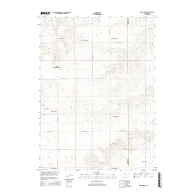
2015 Map of Eagles Nest
USGS Topo · Published 2015About this map
Eagles Nest and the surrounding high plains of Goshen County define this segment of the Wyoming landscape. The terrain is marked by the distinct elevation change of the Goshen Hole Rim, which descends into the broad expanse of Goshen Hole in the southeastern quadrant. This geological transition creates a sharp contrast between the higher plateau and the drainage basins below. Water features are primarily intermittent, represented by Cottonwood Draw and Little Cottonwood Draw, with Cottonwood Falls located in the northwest. The land is partitioned by a network of rural routes, including Deer Creek Rd and Antelope Gap Rd, which follow the natural contours of the canyons and ridges. The boundary between Platte and Goshen Counties runs vertically through the eastern portion of the map, illustrating the administrative divisions in this sparsely populated ranching and grazing region.
Find a feature on this map
20 named features on this map. Tap any name to fly to it.
Don’t see what you’re looking for? This feature index may not catch every label — zoom into the map to look around manually.
Map Details
Editions of this 2015 Eagles Nest Map
This is the sole edition of this map. No revisions or reprints were ever made.
Other maps of this area

1896 · Hartville
USGS Topo · 1:125,000

1901 · Hartville
USGS Topo · 1:125,000

1950 · Rockeagle
USGS Topo · 1:24,000

1950 · Fort Laramie
USGS Topo · 1:24,000

1950 · Register Cliff
USGS Topo · 1:24,000

1951 · Antelope Gap
USGS Topo · 1:24,000
1951 · Wheatland NE
USGS Topo · 1:24,000

1951 · Eagles Nest
USGS Topo · 1:24,000

1952 · Register Cliff
USGS Topo · 1:24,000

1952 · Fort Laramie
USGS Topo · 1:24,000