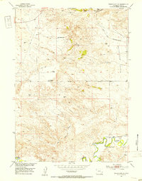
1951 Map of Wheatland NE
USGS Topo · Published 1953About this map
The Oregon Trail winds across the northern landscape of this Platte County region, marking the historic route through the high plains. In the early 1950s, the area remained defined by significant ranching operations, including the Paul Cundall Ranch and the Clair Milton Ranch. These family holdings are situated among the undulating terrain of the Bettelyoun Flats, where water management was critical for survival. To the south, the Laramie River meanders through the valley, supported by the Bright and Southerland Ditch irrigation system. The presence of numerous Windmill sites and the Pipe Line underscores the infrastructure required to sustain livestock and agriculture in this semi-arid environment. Key natural water features such as Box Springs and Warm Springs Can provide further evidence of the essential water sources that dictated the placement of early Wyoming settlements and trails.
Find a feature on this map
14 named features on this map. Tap any name to fly to it.
Don’t see what you’re looking for? This feature index may not catch every label — zoom into the map to look around manually.
Map Details
Editions of this 1951 Wheatland NE Map
2 editions found
Other maps of this area

1896 · Hartville
USGS Topo · 1:125,000

1901 · Hartville
USGS Topo · 1:125,000

1950 · Guernsey
USGS Topo · 1:24,000

1950 · Herman Ranch
USGS Topo · 1:24,000

1950 · Register Cliff
USGS Topo · 1:24,000

1950 · Guernsey Reservoir
USGS Topo · 1:24,000

1951 · Guernsey Reservoir
USGS Topo · 1:24,000
1951 · Herman Ranch
USGS Topo · 1:24,000

1951 · Dwyer
USGS Topo · 1:24,000

1951 · Antelope Gap
USGS Topo · 1:24,000