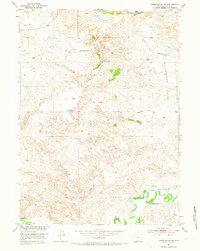
1951 Map of Wheatland NE
USGS Topo · Published 1973About this map
The Emigrant Trail cuts across the northern reaches of this landscape, marking a historic corridor of western movement through Platte County. In the early 1950s, the area remained defined by expansive ranching operations, with family-named holdings such as the Paul Cundall Ranch, Milton Ranch, and Clair Milton Ranch spread across the undulating terrain. To the south, the Laramie River anchors the topography, where the Bright and Southerland Ditch reveals the critical infrastructure of high-plains irrigation. Settlement patterns here are tied closely to water and graze, evident in features like Warm Springs and the expansive Bette Lyoun Flats. Numerous windmills are plotted across the quadrangle, indicating the reliance on groundwater for livestock in this semi-arid environment, while the Don Cundall Ranch sits prominently near the riverbanks.
Find a feature on this map
15 named features on this map. Tap any name to fly to it.
Don’t see what you’re looking for? This feature index may not catch every label — zoom into the map to look around manually.
Map Details
Editions of this 1951 Wheatland NE Map
2 editions found
Other maps of this area

1896 · Hartville
USGS Topo · 1:125,000

1901 · Hartville
USGS Topo · 1:125,000

1950 · Guernsey
USGS Topo · 1:24,000

1950 · Herman Ranch
USGS Topo · 1:24,000

1950 · Register Cliff
USGS Topo · 1:24,000

1950 · Guernsey Reservoir
USGS Topo · 1:24,000

1951 · Guernsey Reservoir
USGS Topo · 1:24,000
1951 · Herman Ranch
USGS Topo · 1:24,000

1951 · Dwyer
USGS Topo · 1:24,000

1951 · Antelope Gap
USGS Topo · 1:24,000