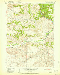
1951 Map of Herman Ranch
USGS Topo · Published 1951About this map
Herman Ranch and other remote outposts like Russel Ranch define this mid-century look at the ranching landscape of Platte County. The North Platte River winds through the northeastern corner, paralleled by the steel of the Chicago Burlington and Quincy railroad. Evidence of the region's deeper history is marked by the Oregon Trail Marker, while the modern era is reflected in the extensive network of Pipe Lines and windmills scattered across the high plains. The drainage systems of Cottonwood Creek and Little Cottonwood Creek carve through the terrain, supporting local agriculture through various Ditches. High points like Pine Ridge and the VABM 5130 Jane survey marker provide orientation in a landscape characterized by its utility and distance, from the Pepper Ranch in the south to the northern river bluffs.
Find a feature on this map
16 named features on this map. Tap any name to fly to it.
Don’t see what you’re looking for? This feature index may not catch every label — zoom into the map to look around manually.
Map Details
Editions of this 1951 Herman Ranch Map
This is the sole edition of this map. No revisions or reprints were ever made.
Other maps of this area

1896 · Hartville
USGS Topo · 1:125,000

1901 · Hartville
USGS Topo · 1:125,000

1950 · Coleman Butte
USGS Topo · 1:24,000

1950 · Herman Ranch
USGS Topo · 1:24,000

1950 · Haushar Ranch
USGS Topo · 1:24,000

1950 · Guernsey Reservoir
USGS Topo · 1:24,000

1951 · Coleman Butte
USGS Topo · 1:24,000

1951 · Sibley Peak
USGS Topo · 1:24,000

1951 · Haushar Ranch
USGS Topo · 1:24,000

1951 · Guernsey Reservoir
USGS Topo · 1:24,000