
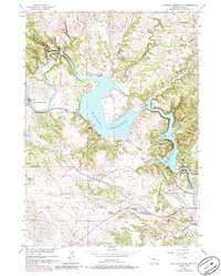
1950 Map of Guernsey Reservoir
USGS Topo · Published 1978About this map
The Emigrant Trail carves through this rugged Platte County landscape, serving as a primary corridor for westward expansion long before the Guernsey Reservoir was impounded. Traces of this historic migration are preserved in markers like the Oregon Trail Marker and the solitary Lucindy Rollins Grave located near the southern bend of the North Platte River. The map captures a transition from pioneer trails to mid-century development, including the Burlington Northern railroad alignment that parallels the water. Settlement is represented by family-held lands such as Frederick Ranch, Wendover Bend Ranch, and Sudbury Ranch. Recreation and public work are evident along the reservoir's fingers, including the Red Cloud Picnic Ground and a site marked CCC Camp (Aband) near Newell Bay, reflecting the legacy of the Civilian Conservation Corps in the region.
Find a feature on this map
34 named features on this map. Tap any name to fly to it.
Don’t see what you’re looking for? This feature index may not catch every label — zoom into the map to look around manually.
Map Details
Editions of this 1950 Guernsey Reservoir Map
2 editions found
Other maps of this area

1896 · Hartville
USGS Topo · 1:125,000

1901 · Hartville
USGS Topo · 1:125,000

1950 · Guernsey
USGS Topo · 1:24,000

1950 · Herman Ranch
USGS Topo · 1:24,000

1950 · Register Cliff
USGS Topo · 1:24,000

1950 · Haushar Ranch
USGS Topo · 1:24,000

1950 · Hell Gap
USGS Topo · 1:24,000

1951 · Haushar Ranch
USGS Topo · 1:24,000

1951 · Guernsey Reservoir
USGS Topo · 1:24,000
1951 · Herman Ranch
USGS Topo · 1:24,000