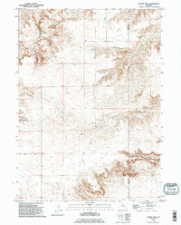
1990 Map of Eagles Nest
USGS Topo · Published 1995About this map
Eagles Nest Canyon defines this high-plains landscape on the boundary of Platte and Goshen Counties. Revised in the 1990s, the map illustrates the persistence of remote ranching and water-management infrastructure in eastern Wyoming. Water sources like Cottonwood Spring and seasonal drainages such as Cottonwood Draw and Deer Creek reveal the vital role of riparian corridors in this arid environment. Human activity is sparse and functional, evidenced by the transit route of Antelope Gap Road, a mapped Pipeline, and a solitary Generator station. This survey is particularly useful for identifying traditional livestock crossings and natural landmarks like Antelope Gap that have guided movement through the region for generations.
Find a feature on this map
11 named features on this map. Tap any name to fly to it.
Don’t see what you’re looking for? This feature index may not catch every label — zoom into the map to look around manually.
Map Details
Editions of this 1990 Eagles Nest Map
This is the sole edition of this map. No revisions or reprints were ever made.
Other maps of this area

1896 · Hartville
USGS Topo · 1:125,000

1901 · Hartville
USGS Topo · 1:125,000

1950 · Rockeagle
USGS Topo · 1:24,000

1950 · Fort Laramie
USGS Topo · 1:24,000

1950 · Register Cliff
USGS Topo · 1:24,000

1951 · Antelope Gap
USGS Topo · 1:24,000
1951 · Wheatland NE
USGS Topo · 1:24,000

1951 · Eagles Nest
USGS Topo · 1:24,000

1952 · Register Cliff
USGS Topo · 1:24,000

1952 · Fort Laramie
USGS Topo · 1:24,000