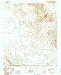
1990 Map of Eagletail Mountains West
USGS Topo · Published 1990About this map
Eagletail Mountains dominate this high desert landscape, characterized by a complex network of arid drainage systems and isolated peaks. Evidence of historical resource extraction is scattered across the northern terrain, most notably at the Eagle Mine, surrounding Open Pit Mines, and various Prospects. This map documents a region where water management was critical for survival and industry, featuring developed collection points like the Triple Eye Catchment, Dead Deer Tank, and Water Tank positioned to capture seasonal runoff.
Find a feature on this map
13 named features on this map. Tap any name to fly to it.
Don’t see what you’re looking for? This feature index may not catch every label — zoom into the map to look around manually.
Map Details
Editions of this 1990 Eagletail Mountains West Map
This is the sole edition of this map. No revisions or reprints were ever made.
Other maps of this area

1942 · Vicksburg
USGS Topo · 1:250,000

1954 · Phoenix
USGS Topo · 1:250,000

1957 · Phoenix
USGS Topo · 1:250,000

1958 · Phoenix
USGS Topo · 1:250,000

1960 · Phoenix
USGS Topo · 1:250,000

1961 · Hope
USGS Topo · 1:62,500

1961 · Lone Mountain
USGS Topo · 1:62,500

1962 · Little Horn Mts
USGS Topo · 1:62,500

1962 · Eagletail Mts
USGS Topo · 1:62,500

1969 · Phoenix
USGS Topo · 1:250,000