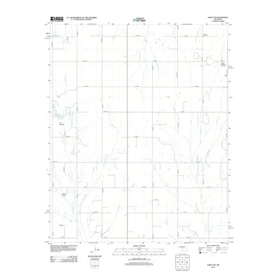
2012 Map of Eakly NE
USGS Topo · Published 2012About this map
Distinctive geological formations like Twin Mounds, Ghost Mound, and the ominously named Dead Woman Mound rise above the agricultural plains of Custer County. This 2012 survey documents a rural Oklahoma landscape organized by a rigid grid of section line roads, including n2450 RD and e1050 RD. The water management of the region is evident through several engineered catchments such as Cartwright Reservoir and the Cobb Cr Site 4 Reservoir, which support the drainage of Fivemile Cr and Lake Cr. For genealogists and local historians, the map identifies significant burial sites including Mound Valley Cem in the north and Bethel Cem along the eastern edge, serving as vital landmarks for tracing family roots in this prairie community.
Find a feature on this map
28 named features on this map. Tap any name to fly to it.
Don’t see what you’re looking for? This feature index may not catch every label — zoom into the map to look around manually.
Map Details
Editions of this 2012 Eakly NE Map
This is the sole edition of this map. No revisions or reprints were ever made.
Other maps of this area

1942 · Geary
USGS Topo · 1:62,500

1951 · Binger
USGS Topo · 1:62,500

1955 · Clinton
USGS Topo · 1:250,000

1957 · Clinton
USGS Topo · 1:250,000

1961 · Eakly
USGS Topo · 1:62,500

1964 · Weatherford
USGS Topo · 1:62,500

1979 · Sickles
USGS Topo · 1:24,000
1979 · Rock Mary
USGS Topo · 1:24,000
1979 · Bridgeport
USGS Topo · 1:24,000

1984 · Eakly
USGS Topo · 1:24,000