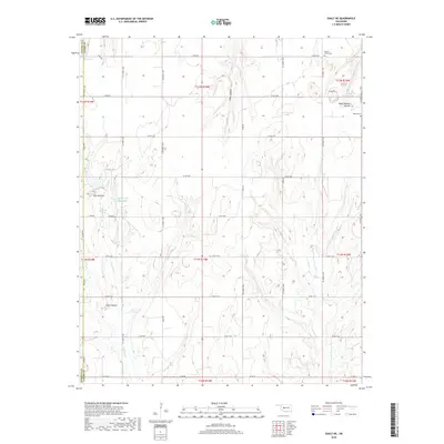
2018 Map of Eakly NE
USGS Topo · Published 2018About this map
Ghost Mound and the distinctive Twin Mounds rise above the section-line roads and rolling agricultural landscape at the intersection of Custer, Washita, and Caddo Counties. This 2018 survey reveals a terrain defined by eroded canyons and carefully managed water resources, including the Cartwright Reservoir and Cobb Cr Site 3 Reservoir tucked into the headwaters of Fivemile Cr. Genealogists and local historians will find the Mound Valley Cem and Bethel Cem situated on high ground near the eastern boundary, serving as quiet landmarks for the surrounding farming communities. The map depicts a late-period rural infrastructure where deep drainage features like Cedar Canyon contrast with the rigid grid of county roads that have organized this part of the Oklahoma plains since the original land runs.
Find a feature on this map
44 named features on this map. Tap any name to fly to it.
Don’t see what you’re looking for? This feature index may not catch every label — zoom into the map to look around manually.
Map Details
Editions of this 2018 Eakly NE Map
This is the sole edition of this map. No revisions or reprints were ever made.
Other maps of this area

1942 · Geary
USGS Topo · 1:62,500

1951 · Binger
USGS Topo · 1:62,500

1955 · Clinton
USGS Topo · 1:250,000

1957 · Clinton
USGS Topo · 1:250,000

1961 · Eakly
USGS Topo · 1:62,500

1964 · Weatherford
USGS Topo · 1:62,500

1979 · Sickles
USGS Topo · 1:24,000
1979 · Rock Mary
USGS Topo · 1:24,000
1979 · Bridgeport
USGS Topo · 1:24,000

1984 · Eakly
USGS Topo · 1:24,000