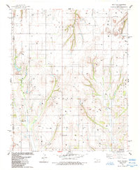
1984 Map of Eakly NE
USGS Topo · Published 1985About this map
Sickles anchors the southeast corner of this Western Oklahoma landscape, which is defined by an active energy economy and distinctive geological formations. The terrain is marked by prominent elevations such as Lone Mound, Dead Woman Mound, and the Twin Mounds, while the deeply carved Hydro Canyon cuts through the northern sections. This mid-1980s data reflects a period of extensive resource extraction, with numerous labels for Oil Well, Gas Well, and Drill Hole scattered across the township lines of Beaver and Texas. Local history and genealogy are anchored in rural sites like the Mound Valley Cem and Bethel Cem. Community life is further evidenced by landmarks like Mt Zion Ch, Pleasant Valley Ch, and the intriguing Ghost Mound located near the headwaters of Fivemile Creek.
Find a feature on this map
26 named features on this map. Tap any name to fly to it.
Don’t see what you’re looking for? This feature index may not catch every label — zoom into the map to look around manually.
Map Details
Editions of this 1984 Eakly NE Map
This is the sole edition of this map. No revisions or reprints were ever made.
Other maps of this area

1942 · Geary
USGS Topo · 1:62,500

1951 · Binger
USGS Topo · 1:62,500

1955 · Clinton
USGS Topo · 1:250,000

1957 · Clinton
USGS Topo · 1:250,000

1961 · Eakly
USGS Topo · 1:62,500

1964 · Weatherford
USGS Topo · 1:62,500

1979 · Sickles
USGS Topo · 1:24,000
1979 · Rock Mary
USGS Topo · 1:24,000
1979 · Bridgeport
USGS Topo · 1:24,000

1984 · Eakly
USGS Topo · 1:24,000