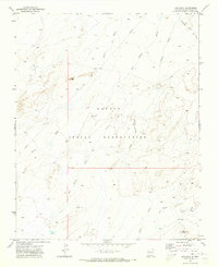
1970 Map of Ear Rock
USGS Topo · Published 1973About this map
The Navajo Indian Reservation landscape is defined by its complex drainage network and unique geological formations as documented in this 1970 field check. Named for a prominent terrain feature, Ear Rock serves as a central landmark amidst a series of ephemeral watercourses including Tocito Wash, Red Willow Wash, and Coyote Wash. The map records a transition in the late 1960s as modern infrastructure began to cross the traditional landscape, evidenced by a large Pipeline cutting across the northwestern and southern sectors.
Find a feature on this map
11 named features on this map. Tap any name to fly to it.
Don’t see what you’re looking for? This feature index may not catch every label — zoom into the map to look around manually.
Map Details
Editions of this 1970 Ear Rock Map
This is the sole edition of this map. No revisions or reprints were ever made.
Other maps of this area

1886 · Wingate
USGS Topo · 1:250,000

1889 · Chaco
USGS Topo · 1:250,000

1892 · Wingate
USGS Topo · 1:250,000

1892 · Chaco
USGS Topo · 1:250,000

1954 · Shiprock
USGS Topo · 1:250,000

1954 · Gallup
USGS Topo · 1:250,000

1958 · Gallup
USGS Topo · 1:250,000

1958 · Shiprock
USGS Topo · 1:250,000

1959 · Shiprock
USGS Topo · 1:250,000

1959 · Gallup
USGS Topo · 1:250,000