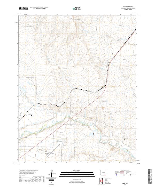
2022 Map of Earl
USGS Topo · Published 2022About this map
The Purgatoire River valley defines this landscape in Las Animas County, where a complex network of historic irrigation systems like Hoehne Ditch, Model Ditch, and the Lewelling Mc Cormick Ditch support high-plains agriculture. The small settlement of Earl serves as a central point along the rail and road corridor, surrounded by numerous ephemeral waterways including Furness Arroyo and Blackwell Arroyo. Genealogists and local historians can locate the Bloom Cem and Wilcox Cem, which remain as distinct markers of early ranching and farming families in this high desert region. The presence of the Perry Stokes Airport and the Gagliardi Reservoir indicate the modern infrastructure that has developed alongside traditional land uses in the western reaches of the quadrangle.
Find a feature on this map
41 named features on this map. Tap any name to fly to it.
Don’t see what you’re looking for? This feature index may not catch every label — zoom into the map to look around manually.
Map Details
Editions of this 2022 Earl Map
This is the sole edition of this map. No revisions or reprints were ever made.
Other maps of this area

1892 · Elmoro
USGS Topo · 1:125,000

1893 · Elmoro
USGS Topo · 1:125,000

1897 · Elmoro
USGS Topo · 1:125,000

1954 · Trinidad
USGS Topo · 1:250,000

1955 · Trinidad
USGS Topo · 1:250,000

1958 · Trinidad
USGS Topo · 1:250,000

1959 · Trinidad
USGS Topo · 1:250,000
1970 · Earl
USGS Topo · 1:24,000
1970 · Mooney Hills
USGS Topo · 1:24,000
1970 · Hoehne
USGS Topo · 1:24,000