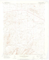
1970 Map of Mooney Hills
USGS Topo · Published 1974About this map
Vigil Cem stands as a quiet focal point in this 1970 landscape of Las Animas County, where the southern plains rise into the distinctive formations of the Mooney Hills. The map details a sophisticated water management system critical to the high desert, featuring the prominent South Side Ditch and numerous seasonal drainages like Patton Arroyo and Frijole Creek. These waterways and arroyos define the terrain's character, illustrating the essential relationship between the land's natural contours and the human efforts to divert water for local use. Transport and logistics in this part of Colorado are represented by the Colorado and Southern line, which cuts through the southwestern corner, connecting this isolated ranching country to broader regional markets. The presence of several family-named landmarks and the local cemetery provides valuable geographic context for those researching the early settlement patterns of the Purgatoire River valley vicinity.
Find a feature on this map
13 named features on this map. Tap any name to fly to it.
Don’t see what you’re looking for? This feature index may not catch every label — zoom into the map to look around manually.
Map Details
Editions of this 1970 Mooney Hills Map
This is the sole edition of this map. No revisions or reprints were ever made.
Other maps of this area

1892 · Elmoro
USGS Topo · 1:125,000

1893 · Elmoro
USGS Topo · 1:125,000

1897 · Elmoro
USGS Topo · 1:125,000

1954 · Trinidad
USGS Topo · 1:250,000

1955 · Trinidad
USGS Topo · 1:250,000

1958 · Trinidad
USGS Topo · 1:250,000

1959 · Trinidad
USGS Topo · 1:250,000
1970 · Earl
USGS Topo · 1:24,000
1970 · Hoehne
USGS Topo · 1:24,000
1971 · Barela
USGS Topo · 1:24,000