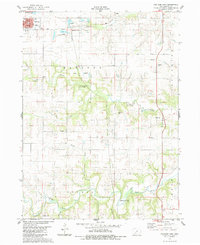
1983 Map of Earlham East
USGS Topo · Published 1984About this map
The town of Earlham serves as the primary hub in this portion of Madison County, showing its established grid just south of the Sewage Disposal Ponds. The landscape is defined by the branching waterways of the North River and Bulger Creek, which have carved deep drainages through the agricultural terrain. This 1980s landscape reveals a high concentration of pioneer and community burial grounds, including North Branch Cem, Bennett Cem, and Trester Cem, marking the early settlement patterns of Jefferson and Douglas townships. Along the southern banks of the river, the Hogback Covered Bridge stands as a notable structural landmark of the region's transportation history. The local economy is visibly tied to the land, with numerous quarries dotting the hillsides near North Branch, while recreational and natural spaces are preserved at Goeldner Woods County Park.
Find a feature on this map
23 named features on this map. Tap any name to fly to it.
Don’t see what you’re looking for? This feature index may not catch every label — zoom into the map to look around manually.
Map Details
Editions of this 1983 Earlham East Map
This is the sole edition of this map. No revisions or reprints were ever made.
Other maps of this area

1908 · Waukee
USGS Topo · 1:62,500

1949 · Adel
USGS Topo · 1:62,500

1951 · Adel
USGS Topo · 1:62,500

1951 · St. Charles
USGS Topo · 1:62,500

1952 · Winterset
USGS Topo · 1:62,500

1954 · Omaha
USGS Topo · 1:250,000

1954 · Des Moines
USGS Topo · 1:250,000

1956 · Des Moines
USGS Topo · 1:250,000

1957 · Des Moines
USGS Topo · 1:250,000

1957 · Omaha
USGS Topo · 1:250,000