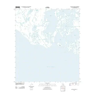
2012 Map of East Bay Junop
USGS Topo · Published 2012About this map
Gulf of Mexico tides dictate the landscape of this coastal Terrebonne Parish region, where the intricate transition from marsh to open water creates a maze of brackish channels and shallow basins. Central to the coastal boundary is Pelican Island, situated just off the mainland where the waters of Caillou Bay meet the inner marsh. The naming conventions found on the map, such as Hellhole Bayou and Big Hellhole Lake, suggest the challenging nature of navigating this water-logged terrain for early inhabitants and commercial mariners. A complex network of waterways, including the winding Bayou l'Ourse and the secluded Old Oyster Bayou Lake, illustrates the fragile hydrography of the Louisiana coastline during the early twenty-first century. These labels reflect a history of local maritime use, from oyster harvesting to navigation through narrow passes like Cross Bayou and Rat Bayou.
Find a feature on this map
13 named features on this map. Tap any name to fly to it.
Don’t see what you’re looking for? This feature index may not catch every label — zoom into the map to look around manually.
Map Details
Editions of this 2012 East Bay Junop Map
This is the sole edition of this map. No revisions or reprints were ever made.
Other maps of this area

1894 · Bayou De Large
USGS Topo · 1:62,500

1932 · Lake Decade
USGS Topo · 1:62,500

1935 · Lake Mechant
USGS Topo · 1:31,680

1935 · Oyster Bayou
USGS Topo · 1:62,500

1940 · Bayou Du Large
USGS Topo · 1:62,500

1941 · Bayou Du Large
USGS Topo · 1:62,500

1944 · Bayou Du Large
USGS Topo · 1:62,500

1945 · New Orleans
USGS Topo · 1:250,000
1947 · West Derniere
USGS Topo · 1:31,680

1949 · Grand Bayou Du Large
USGS Topo · 1:31,680