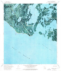
1974 Map of East Bay Junop
USGS Topo · Published 1976About this map
Old Oyster Bayou Lake and the labyrinthine marshlands of southern Terrebonne Parish dominate this 1970s orthophotomap, where the land fragmentizes into the Gulf of Mexico. The landscape is defined by a dense network of tidal channels including Taylors Bayou, Junop Bayou, and the curiously named Hellhole Bayou. This era of coastal mapping shows the industrial footprint of the region through numerous Drill Holes and a prominent Pipeline cutting across the wetlands toward Bay Junop. Near the southern edge, Pelican Island and Pelican Pass guard the entrance to Caillou Bay, illustrating the fragile transition between the interior bayous and the open sea. The map's photographic base provides a rare record of the shoreline and marsh density before decades of coastal erosion further altered these intricate waterways.
Find a feature on this map
32 named features on this map. Tap any name to fly to it.
Don’t see what you’re looking for? This feature index may not catch every label — zoom into the map to look around manually.
Map Details
Editions of this 1974 East Bay Junop Map
This is the sole edition of this map. No revisions or reprints were ever made.
Other maps of this area

1894 · Bayou De Large
USGS Topo · 1:62,500

1932 · Lake Decade
USGS Topo · 1:62,500

1935 · Lake Mechant
USGS Topo · 1:31,680

1935 · Oyster Bayou
USGS Topo · 1:62,500

1940 · Bayou Du Large
USGS Topo · 1:62,500

1941 · Bayou Du Large
USGS Topo · 1:62,500

1944 · Bayou Du Large
USGS Topo · 1:62,500

1945 · New Orleans
USGS Topo · 1:250,000
1947 · West Derniere
USGS Topo · 1:31,680

1949 · Grand Bayou Du Large
USGS Topo · 1:31,680