1969 Map of East Brookfield
USGS Topo · Published 1972About this map
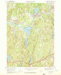
The Quaboag River and its massive expansion at Quaboag Pond anchor this detailed landscape in central Massachusetts, reflecting a region defined by its glacial lakes and industrial rail corridors. Near the village of Brookfield, the Penn Central line parallels the river, serving as the backbone for local commerce and connectivity. To the south, the terrain rises toward Walker Mountain and Hitchcock Mountain, where Wells State Park preserves the upland woods. This survey documents the mid-century layout of historic town centers, capturing the spatial relationship between old burying grounds like Holy Rosary Cem and Podunk Cem and the expanding recreational areas around Lake Lashaway and Walker Pond. The presence of the Brookfield Airport and the Mass Turnpike cutting through the southern townships highlights the era's shift toward modern automotive and aerial transit while traditional crossroads like Rice Corner Crossroads remain intact.
Find a feature on this map
76 named features on this map. Tap any name to fly to it.
Don’t see what you’re looking for? This feature index may not catch every label — zoom into the map to look around manually.
Map Details
Editions of this 1969 East Brookfield Map
2 editions found

Other maps of this area

1885 · Worcester
USGS Topo · 1:62,500

1886 · Worcester
USGS Topo · 1:62,500

1887 · Brookfield
USGS Topo · 1:62,500

1887 · Barre
USGS Topo · 1:62,500

1889 · Webster
USGS Topo · 1:62,500

1889 · Barre
USGS Topo · 1:62,500

1890 · Brookfield
USGS Topo · 1:62,500

1892 · Webster
USGS Topo · 1:62,500

1892 · Worcester
USGS Topo · 1:62,500

1893 · Brookfield
USGS Topo · 1:62,500