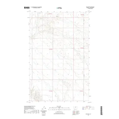
2020 Map of East Butte
USGS Topo · Published 2020About this map
East Butte dominates this high-plains landscape in Blaine County, serving as a prominent geographical anchor for the surrounding prairie. This 2020 survey by the U.S. Geological Survey captures a remote corner of northern Montana where the drainage patterns of several intermittent waterways define the topography. The headwaters and seasonal flows of Wayne Creek, including its West Fork and South Fork, carve out the terrain alongside Forgey Creek and West Forgey Creek. The rural infrastructure is light, centered primarily on Hogeland Road running along the eastern boundary. Notable water sources like Box Spring in the northwest corner underscore the importance of reliable water points in this arid ranching and grazing country, where township lines like t35n r22e and t34n r23e mark the enduring Public Land Survey System grid.
Find a feature on this map
14 named features on this map. Tap any name to fly to it.
Don’t see what you’re looking for? This feature index may not catch every label — zoom into the map to look around manually.
Map Details
Editions of this 2020 East Butte Map
This is the sole edition of this map. No revisions or reprints were ever made.
Other maps of this area

1903 · Wayne Creek
USGS Topo · 1:62,500

1905 · Wayne Creek
USGS Topo · 1:62,500

1905 · Harlem
USGS Topo · 1:62,500

1913 · Cherry Ridge
USGS Topo · 1:125,000

1953 · Havre
USGS Topo · 1:250,000

1957 · Havre
USGS Topo · 1:250,000

1958 · Havre
USGS Topo · 1:250,000
1964 · Grable Coulee
USGS Topo · 1:24,000
1964 · Fort Belknap Siding
USGS Topo · 1:24,000
1964 · Harlem
USGS Topo · 1:24,000