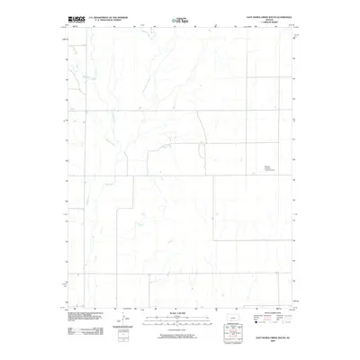
2009 Map of East Kiowa Creek South
USGS Topo · Published 2009About this map
East Kiowa Creek and its neighboring tributaries define the drainage patterns of this rural Comanche County landscape in the early 21st century. The terrain is characterized by the winding paths of West Kiowa Creek and Kiowa Creek, which converge as they move through the undulating plains. A notable human mark on this agricultural expanse is the Seacat Brothers Landing Strip, a private aviation feature that reflects the modern necessity for aerial transport in expansive ranching and farming operations. To the north, the headwaters of Wiggins Creek cut through the soil, illustrating the subtle elevation changes that guide water toward the larger creek systems. This survey documents the network of section roads and watercourses before significant contemporary development, maintaining a focus on the essential land features and private infrastructure of the Kansas prairie.
Find a feature on this map
5 named features on this map. Tap any name to fly to it.
Don’t see what you’re looking for? This feature index may not catch every label — zoom into the map to look around manually.
Map Details
Editions of this 2009 East Kiowa Creek South Map
This is the sole edition of this map. No revisions or reprints were ever made.
Other maps of this area

1892 · Coldwater
USGS Topo · 1:125,000

1894 · Sitka
USGS Topo · 1:62,500

1896 · Ashland
USGS Topo · 1:125,000

1955 · Pratt
USGS Topo · 1:250,000

1959 · Pratt
USGS Topo · 1:250,000

1979 · Sugarloaf
USGS Topo · 1:24,000

1979 · Turkey Creek
USGS Topo · 1:24,000

1979 · Coldwater
USGS Topo · 1:24,000

1979 · East Kiowa Creek South
USGS Topo · 1:24,000
1979 · East Kiowa Creek North
USGS Topo · 1:24,000