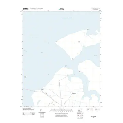
2011 Map of East Lake
USGS Topo · Published 2011About this map
East Lake and its surrounding wetlands define this coastal landscape on the edge of the Albemarle Sound. The settlement of East Lake is clustered along the shoreline near East Lake Landing, where the terrestrial landscape begins to fragment into the tidal reaches of the Alligator River. To the east, the community of Lake Neighborhood is connected by local routes like Lake Neighborhood Rd and Briar Hall, tracing the habitable ground between South Lake and the sound. The geography is marked by numerous named points and coastal features, such as Durant Island and Briery Hall Point, which suggest a long history of maritime navigation and local reliance on these waterways. This map documents a region where the boundary between land and water is constantly shifting, shaped by features like Sandy Point Shoal and Middle Ground.
Find a feature on this map
19 named features on this map. Tap any name to fly to it.
Don’t see what you’re looking for? This feature index may not catch every label — zoom into the map to look around manually.
Map Details
Editions of this 2011 East Lake Map
This is the sole edition of this map. No revisions or reprints were ever made.
Other maps of this area

1940 · Powells Point
USGS Topo · 1:62,500

1940 · Wade Point
USGS Topo · 1:62,500

1943 · Wade Point
USGS Topo · 1:62,500

1943 · Columbia
USGS Topo · 1:125,000

1943 · Roanoke Island
USGS Topo · 1:125,000

1946 · Eastville
USGS Topo · 1:250,000

1946 · Currituck Sound
USGS Topo · 1:250,000

1948 · Wade Point
USGS Topo · 1:62,500

1953 · Norfolk
USGS Topo · 1:250,000

1953 · Buffalo City
USGS Topo · 1:24,000