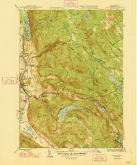
1948 Map of East Lee
USGS Topo · Published 1948About this map
The Housatonic River corridor defines this 1948 survey of the Berkshires, tracing the industrial and transit spine between Lee and Lenox. This era shows the New York New Haven and Hartford railroad running parallel to the river through Lenoxdale, supporting the mill towns of the valley. To the east, the landscape shifts abruptly into the high, wooded elevations of October Mountain and Washington Mountain.
Find a feature on this map
65 named features on this map. Tap any name to fly to it.
Don’t see what you’re looking for? This feature index may not catch every label — zoom into the map to look around manually.
Map Details
Editions of this 1948 East Lee Map
2 editions found
Other maps of this area

1885 · Sheffield
USGS Topo · 1:62,500

1886 · Becket
USGS Topo · 1:62,500

1888 · Sheffield
USGS Topo · 1:62,500

1888 · Becket
USGS Topo · 1:62,500

1888 · Sandisfield
USGS Topo · 1:62,500

1888 · Pittsfield
USGS Topo · 1:62,500

1890 · Pittsfield
USGS Topo · 1:62,500

1891 · Sheffield
USGS Topo · 1:62,500

1893 · Becket
USGS Topo · 1:62,500

1893 · Sheffield
USGS Topo · 1:62,500