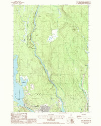
1988 Map of East Millinocket
USGS Topo · Published 1988About this map
East Millinocket and the settlement at Grindstone anchor this late-1980s landscape dominated by the winding path of the East Branch Penobscot River. The industrial and transport character of the era is evident in the presence of the Bangor and Aroostook railroad line and a Gravel Pit near the riverbanks. The river itself transitions through varying degrees of intensity, marked by Grindstone Falls, Meadow Brook Rapids, and Ledge Falls. These features, combined with the managed waters of Dolby Pond and its Partridge Brook Flowage, reflect the significant role of the river in the regional economy. Beyond the main settlements, the map records more isolated landmarks such as Wadleigh Deadwater and a local Cem, providing valuable coordinates for genealogists tracing families in the Medway and East Millinocket townships.
Find a feature on this map
28 named features on this map. Tap any name to fly to it.
Don’t see what you’re looking for? This feature index may not catch every label — zoom into the map to look around manually.
Map Details
Editions of this 1988 East Millinocket Map
This is the sole edition of this map. No revisions or reprints were ever made.
Other maps of this area

1940 · Sherman
USGS Topo · 1:62,500

1940 · Mattawamkeag
USGS Topo · 1:62,500

1942 · Mattawamkeag
USGS Topo · 1:62,500

1942 · Sherman
USGS Topo · 1:62,500

1951 · Millinocket
USGS Topo · 1:62,500

1953 · Stacyville
USGS Topo · 1:62,500

1954 · Millinocket
USGS Topo · 1:250,000

1958 · Millinocket
USGS Topo · 1:250,000

1960 · Millinocket
USGS Topo · 1:250,000

1975 · Millinocket SW
USGS Topo · 1:24,000