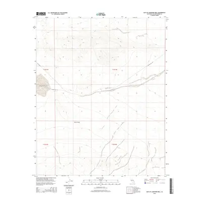
2015 Map of East of Langford Well
USGS Topo · Published 2015About this map
Langford Well Lake sits at the heart of this arid landscape, a distinctive dry lakebed feature characteristic of the northern Mojave Desert. The map documents a sparsely developed military or restricted region within San Bernardino County, where transportation is defined by specialized corridors such as the Ammo Route and Langford Lake Rd. These routes provide the primary access through a terrain marked by subtle elevation changes and the desert floor's natural drainage patterns. The layout of section lines across township boundaries like t13n r3e and t13n r4e suggests a landscape managed for utility and strategic purposes rather than civilian settlement. This 2015 survey captures the intersection of desert geography and modern land management, offering a precise view of the road networks that traverse the basin floor.
Find a feature on this map
8 named features on this map. Tap any name to fly to it.
Don’t see what you’re looking for? This feature index may not catch every label — zoom into the map to look around manually.
Map Details
Editions of this 2015 East of Langford Well Map
This is the sole edition of this map. No revisions or reprints were ever made.
Other maps of this area

1933 · Avawatz Mountains
USGS Topo · 1:250,000

1947 · Trona
USGS Topo · 1:250,000
1948 · Red Pass Lake
USGS Topo · 1:62,500

1948 · Trona
USGS Topo · 1:250,000
1948 · Alvord Mountain
USGS Topo · 1:62,500
1948 · Cave Mountain
USGS Topo · 1:62,500
1948 · Tiefort Mountains
USGS Topo · 1:62,500
1951 · Tiefort Mountains
USGS Topo · 1:62,500
1951 · Cave Mountain
USGS Topo · 1:62,500
1951 · Alvord Mountain
USGS Topo · 1:62,500