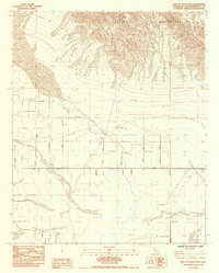
1984 Map of East of Valley Mtn.
USGS Topo · Published 1985About this map
The Bullion Mountains dominate the northern terrain of this Mojave Desert landscape, casting a sharp contrast against the organized grid of roads and infrastructure to the south. This 1984 provisional survey illustrates a transition between the rocky highlands and the flat basin, where industrial and utility markers like a major Gas Pipeline and various Prospect points suggest a history of resource exploration. Local transit is defined by a network of named desert tracks, including Amboy Road and Shadow Mtn Road, which provide access to this arid interior. Of particular interest to researchers are the Diversion Dams and scattered Ruins located near the southern sections of the map, indicating previous efforts to manage water or establish settlements in this challenging environment. The alignment of roads such as Virginia Road and Chadwick Rd reflects a sparse but deliberate human footprint across the San Bernardino County desert floor during the late twentieth century.
Find a feature on this map
22 named features on this map. Tap any name to fly to it.
Don’t see what you’re looking for? This feature index may not catch every label — zoom into the map to look around manually.
Map Details
Editions of this 1984 East of Valley Mtn. Map
This is the sole edition of this map. No revisions or reprints were ever made.
Other maps of this area

1942 · Amboy
USGS Topo · 1:250,000

1943 · Amboy
USGS Topo · 1:250,000

1954 · Needles
USGS Topo · 1:250,000

1954 · Bristol Lake SW
USGS Topo · 1:24,000

1954 · Valley Mtn
USGS Topo · 1:24,000

1955 · Lead Mountain SW
USGS Topo · 1:24,000
1955 · Cleghorn Lakes
USGS Topo · 1:24,000

1955 · Lead Mountain
USGS Topo · 1:62,500

1956 · Needles
USGS Topo · 1:250,000

1956 · Dale Lake
USGS Topo · 1:62,500