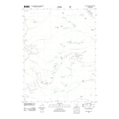
2011 Map of East Portal
USGS Topo · Published 2011About this map
East Portal serves as a critical junction for high-altitude transit and resource extraction along the Continental Divide. This area is defined by the engineering legacy of the Moffat Tunnel and the historical crossing at Rollins Pass, where the Needle Eye Tunnel remains a landmark for travelers navigating the mountain crest. The terrain is marked by the industrial footprints of the Mountain Goat Mine, Blue Stones Mine, and Gold Spring Group Mine, reflecting a long history of mineral prospecting in the Colorado peaks. A dense network of glacial lakes and reservoirs, including Skyscraper Reservoir, Yankee Doodle Lake, and Jasper Lake, feeds numerous drainages like Jasper Creek and South Boulder Creek. Local landmarks like Riflesight Notch and Devils Thumb provide distinct orientation points within this high-alpine landscape, while the Buckingham Campground anchors the northern end of the map's geography.
Find a feature on this map
64 named features on this map. Tap any name to fly to it.
Don’t see what you’re looking for? This feature index may not catch every label — zoom into the map to look around manually.
Map Details
Editions of this 2011 East Portal Map
This is the sole edition of this map. No revisions or reprints were ever made.
Other maps of this area

1905 · Central City
USGS Topo · 1:62,500

1910 · Central City
USGS Topo · 1:62,500

1912 · Central City
USGS Topo · 1:62,500

1915 · Longs Peak
USGS Topo · 1:125,000

1919 · Rocky Mountain National Park
USGS Topo · 1:125,000

1924 · Fraser
USGS Topo · 1:62,500

1926 · Fraser
USGS Topo · 1:62,500

1942 · Nederland
USGS Topo · 1:24,000

1942 · Central City
USGS Topo · 1:24,000
1944 · Nederland
USGS Topo · 1:31,680
Featured Places
- Buckingham Campground, CO
- Diamond Lake Campground, CO
- East Portal Distributed Camping Area, CO
- Winter Park, CO
- Grand County, CO