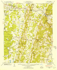
1943 Map of East Ridge
USGS Topo · Published 1957About this map
South Chickamauga Creek and its many tributaries wind through the ridge-and-valley terrain of the Tennessee-Georgia border, where agricultural and industrial development followed the natural topography. The Nashville Chattanooga and St Louis railroad cuts through the landscape, supporting communities like Graysville and East Ridge. This 1943 field examination reflects a rural society anchored by country institutions, including Spring Creek Ch, West Side Sch, and numerous family burial grounds like Dixon Cem and Julian Cem.
Find a feature on this map
48 named features on this map. Tap any name to fly to it.
Don’t see what you’re looking for? This feature index may not catch every label — zoom into the map to look around manually.
Map Details
Editions of this 1943 East Ridge Map
This is the sole edition of this map. No revisions or reprints were ever made.
Other maps of this area

1886 · Ringgold
USGS Topo · 1:125,000

1888 · Chattanooga
USGS Topo · 1:125,000

1892 · Ringgold
USGS Topo · 1:125,000

1893 · Chattanooga
USGS Topo · 1:125,000

1935 · East Chattanooga
USGS Topo · 1:24,000

1935 · East Ridge
USGS Topo · 1:24,000

1935 · Ringgold
USGS Topo · 1:24,000

1935 · Nickajack Gap
USGS Topo · 1:24,000

1935 · Ooltewah
USGS Topo · 1:24,000

1935 · Tunnel Hill
USGS Topo · 1:24,000