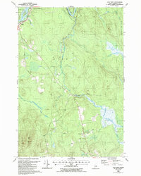
1988 Map of East Winn
USGS Topo · Published 1988About this map
The Penobscot River and Mattawamkeag River converge in this corner of Penobscot County, shaping a landscape defined by water and heavy forestry. Small settlements like East Winn and Crockertown are linked by rural routes including Phillips Road and North Road, while numerous Gravel Pits indicate the local extractive industry during the late twentieth century. Genealogists will find the East Winn Cem and the C&MA Ch as key landmarks for local family history research. The topography is dominated by the marshy reaches of Contrary Brook Bog and the rising elevation of Rollins Mtn, illustrating the varied terrain between the river valleys. The map also documents the many small tributaries like Mattakeunk Stream and Salmon Stream that feed the region's prominent waterways.
Find a feature on this map
36 named features on this map. Tap any name to fly to it.
Don’t see what you’re looking for? This feature index may not catch every label — zoom into the map to look around manually.
Map Details
Editions of this 1988 East Winn Map
This is the sole edition of this map. No revisions or reprints were ever made.
Other maps of this area

1920 · Winn
USGS Topo · 1:62,500

1931 · Springfield
USGS Topo · 1:48,000

1934 · Springfield
USGS Topo · 1:62,500

1940 · Mattawamkeag
USGS Topo · 1:62,500

1941 · Wytopitlock
USGS Topo · 1:62,500

1942 · Mattawamkeag
USGS Topo · 1:62,500

1943 · Wytopitlock
USGS Topo · 1:62,500

1954 · Millinocket
USGS Topo · 1:250,000

1958 · Millinocket
USGS Topo · 1:250,000

1960 · Millinocket
USGS Topo · 1:250,000