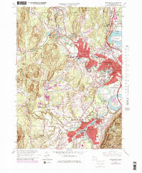
1964 Map of Easthampton
USGS Topo · Published 1979About this map
The Connecticut River and its dramatic Oxbow anchor this 1964 study of the Pioneer Valley, where industrial centers and academic institutions define the landscape. The city of Northampton is a focal point, showing the sprawling campuses of Smith College and the Northampton State Hospital. Further south, the town of Easthampton is marked by its manufacturing legacy, evidenced by Rubber Thread Pond and the Lower Millpond situated along the Manhan River.
Find a feature on this map
71 named features on this map. Tap any name to fly to it.
Don’t see what you’re looking for? This feature index may not catch every label — zoom into the map to look around manually.
Map Details
Editions of this 1964 Easthampton Map
3 editions found
Other maps of this area

1885 · Northampton
USGS Topo · 1:62,500

1886 · Springfield
USGS Topo · 1:62,500

1886 · Chesterfield
USGS Topo · 1:62,500

1886 · Northampton
USGS Topo · 1:62,500

1887 · Granville
USGS Topo · 1:62,500

1888 · Chesterfield
USGS Topo · 1:62,500

1889 · Springfield
USGS Topo · 1:62,500

1889 · Granville
USGS Topo · 1:62,500

1891 · Northampton
USGS Topo · 1:62,500

1893 · Northampton
USGS Topo · 1:62,500