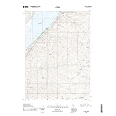
2018 Map of Eastman
USGS Topo · Published 2018About this map
The Mississippi River forms the western boundary of this Crawford County landscape, where the rugged driftless terrain rises sharply into prominent landforms like Du Charme Ridge and Wall Ridge. In the village of Eastman, local heritage is anchored by Saint Wenceslaus Ch, its associated Saint Wenceslaus Cem, and a National Cem. To the north, the riverfront settlement of Lynxville sits at the base of the bluffs near Morgan Hollow. The map reveals a complex network of ridges and coulees, with agricultural life following the high ground along routes such as Benhardt Ridge Rd and Swatek Ridge Rd. The river corridor itself is a maze of backwaters and islands, including Harpers Slough, Saint Paul Slough, and the specifically designated Island Number One Hundred Fifty-nine.
Find a feature on this map
64 named features on this map. Tap any name to fly to it.
Don’t see what you’re looking for? This feature index may not catch every label — zoom into the map to look around manually.
Map Details
Editions of this 2018 Eastman Map
This is the sole edition of this map. No revisions or reprints were ever made.
Other maps of this area

1903 · Waukon
USGS Topo · 1:125,000

1924 · Gays Mills
USGS Topo · 1:62,500

1926 · Gays Mills
USGS Topo · 1:62,500

1926 · Wauzeka
USGS Topo · 1:62,500

1929 · Ferryville
USGS Topo · 1:62,500

1929 · Prairie Du Chien
USGS Topo · 1:62,500

1932 · Ferryville
USGS Topo · 1:62,500

1932 · Prairie Du Chien
USGS Topo · 1:62,500

1958 · La Crosse
USGS Topo · 1:250,000

1961 · La Crosse
USGS Topo · 1:250,000