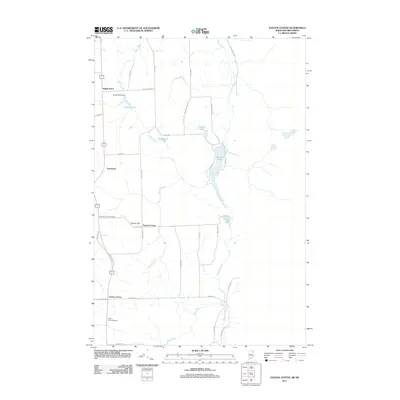
2011 Map of Easton Center
USGS Topo · Published 2011About this map
Easton Center serves as a primary reference point in this northeastern Maine landscape, where agricultural roads and waterways define the community structure. The terrain is marked by a network of small ponds and brooks, including Bryant Pond, regulated by the Bryant Pond Dam, and the winding course of the River De Chute to the south. Small settlements like Maple Grove, Fairmount, and Powers Corner appear along the north-south corridors, reflecting the area’s rural residential and farming heritage. For those researching local family history, the presence of the Pine Tree Church Cemetery and Mount Shilo Cemetery provides specific locations for genealogical inquiry. The map also captures the local road network, from Ladner RD to Monson Mill RD, illustrating the connectivity between scattered homesteads and larger water features such as Monson Pond and Fischer Lake.
Find a feature on this map
40 named features on this map. Tap any name to fly to it.
Don’t see what you’re looking for? This feature index may not catch every label — zoom into the map to look around manually.
Map Details
Editions of this 2011 Easton Center Map
This is the sole edition of this map. No revisions or reprints were ever made.
Other maps of this area

1930 · Fort Fairfield
USGS Topo · 1:48,000

1933 · Fort Fairfield
USGS Topo · 1:62,500

1936 · Mars Hill
USGS Topo · 1:48,000

1940 · Mars Hill
USGS Topo · 1:62,500

1951 · Mars Hill
USGS Topo · 1:62,500

1951 · Fort Fairfield
USGS Topo · 1:62,500

1959 · Woodstock
USGS Topo · 1:250,000

1963 · Woodstock
USGS Topo · 1:250,000
1975 · Mars Hill NW
USGS Topo · 1:24,000
1975 · Fort Fairfield SE
USGS Topo · 1:24,000