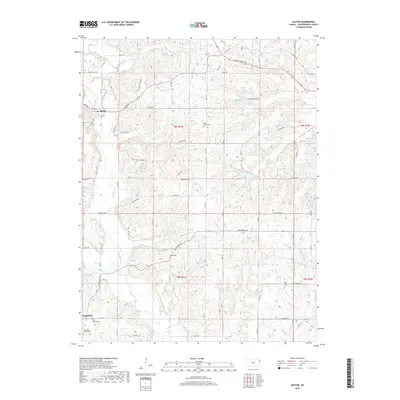
2018 Map of Easton
USGS Topo · Published 2018About this map
Stranger Creek and its many tributaries, including Buckhorn Creek and Buttermilk Creek, carve a complex drainage pattern across this Leavenworth County landscape. The settlement of Easton serves as a local hub near the northwestern corner, while the community of Springdale anchors the southwestern section. The map reveals a high density of rural burial grounds, such as Springdale Friends Cemetery and Saint Thomas Cemetery, which offer significant value for genealogists tracing early families in the region. Transportation follows both modern sections and historical paths, notably the Santa Fe Trail crossing the northeastern corner. Smaller landmarks like Risky Airport and Happy Hollow Lake provide contemporary context to a landscape still defined by its traditional agricultural divisions and the prominent Salt Creek Valley to the east.
Find a feature on this map
53 named features on this map. Tap any name to fly to it.
Don’t see what you’re looking for? This feature index may not catch every label — zoom into the map to look around manually.
Map Details
Editions of this 2018 Easton Map
This is the sole edition of this map. No revisions or reprints were ever made.
Other maps of this area
1886 · Oskaloosa
USGS Topo · 1:125,000
1888 · Oskaloosa
USGS Topo · 1:125,000
1890 · Kansas City
USGS Topo · 1:125,000
1894 · Kansas City
USGS Topo · 1:125,000
1894 · Oskaloosa
USGS Topo · 1:125,000
1910 · Leavenworth
USGS Topo · 1:62,500
1934 · Bonner Springs
USGS Topo · 1:48,000
1940 · Bonner Springs
USGS Topo · 1:62,500
1948 · Oak Mills
USGS Topo · 1:24,000
1948 · Leavenworth
USGS Topo · 1:62,500