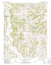
1984 Map of Easton
USGS Topo · Published 1984About this map
Stranger Creek winds through the heart of Leavenworth County, anchoring a landscape shaped by petroleum extraction and small-town agricultural life in the early 1980s. The northern reaches are dominated by the industrial footprint of the Easton Oil Field, where numerous Oil Wells pepper the terrain between Cramer Creek and Buckhorn Creek. This energy production exists alongside a long-standing community network of rural churches and cemeteries, such as the St Joseph of the Valley Ch and the High Prairie Ch.
Find a feature on this map
37 named features on this map. Tap any name to fly to it.
Don’t see what you’re looking for? This feature index may not catch every label — zoom into the map to look around manually.
Map Details
Editions of this 1984 Easton Map
This is the sole edition of this map. No revisions or reprints were ever made.
Other maps of this area

1886 · Oskaloosa
USGS Topo · 1:125,000

1888 · Oskaloosa
USGS Topo · 1:125,000

1890 · Kansas City
USGS Topo · 1:125,000

1894 · Kansas City
USGS Topo · 1:125,000

1894 · Oskaloosa
USGS Topo · 1:125,000

1910 · Leavenworth
USGS Topo · 1:62,500

1934 · Bonner Springs
USGS Topo · 1:48,000

1940 · Bonner Springs
USGS Topo · 1:62,500

1948 · Oak Mills
USGS Topo · 1:24,000

1948 · Leavenworth
USGS Topo · 1:62,500