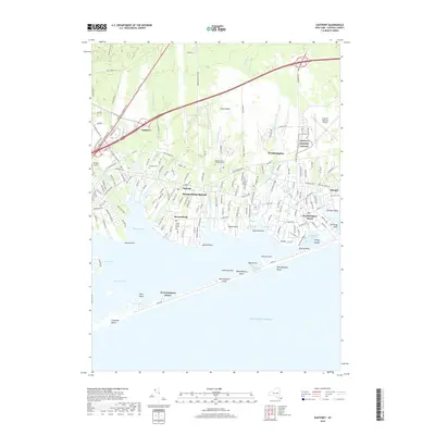
2019 Map of Eastport
USGS Topo · Published 2019About this map
Seatuck Cove and the finger-like inlets of Tanner-Neck and Oneck characterize this maritime portion of the Long Island south shore. The landscape transitions from the suburbanized corridors of the Long Island RR and Sunrise Hwy to the ecologically complex wetlands of Moriches Bay. Historical burial sites such as the Tuthill Burial Ground and Eastport Cem are situated inland, while the coastal reaches are defined by a series of points and beaches, including Speonk Point and Apacuck Point. The presence of the Francis S Gabreski Airport and Spadaro Airport highlights the region's mid-century aviation role. Along the outer barrier, West Hampton Dunes and Westhampton Island separate the quiet waters of the bay from the Atlantic Ocean, illustrating the delicate geomorphology of the New York coastline.
Find a feature on this map
50 named features on this map. Tap any name to fly to it.
Don’t see what you’re looking for? This feature index may not catch every label — zoom into the map to look around manually.
Map Details
Editions of this 2019 Eastport Map
This is the sole edition of this map. No revisions or reprints were ever made.
Other maps of this area

1903 · Riverhead
USGS Topo · 1:62,500

1904 · Riverhead
USGS Topo · 1:62,500

1904 · Moriches
USGS Topo · 1:62,500

1943 · Riverhead
USGS Topo · 1:62,500

1947 · Mattituck
USGS Topo · 1:24,000

1947 · Riverhead
USGS Topo · 1:24,000

1947 · Quogue
USGS Topo · 1:24,000

1947 · Eastport
USGS Topo · 1:24,000

1949 · New York
USGS Topo · 1:250,000

1954 · New York
USGS Topo · 1:250,000